EPIC Aerosol Optical Centroid Height (AOCH) Product
The AOCH data product is a new dataset generated from the EPIC's Level-1B data. It contains two key scientific variables, AOCH and aerosol optical depth (AOD). Currently, AOCH is only retrieved for absorbing (dust or smoke) aerosols for AOD larger than 0.2 at 680 nm. The algorithm theoretical basis and the algorithm implementation for AOCH and AOD retrievals can be found in Xu et al. (2017), Xu et al. (2019), and Lu et al. (2021). Currently, the AOCH algorithm is also extended to TROPOMI by Chen et al. (2021), with significant modification and advancement. The scientific application of AOCH data products can also be found in aforementioned papers as well as in Lu et al. (2022). Users are highly recommended to refer to these papers and contact with algorithm developers before applying the dataset for their own research and application.
What is AOCH and how to validate it? AOCH is retrieved from a combined use of O2 A and B absorption bands and their respective continuum bands of EPIC, while AOD is retrieved from the blue (433 nm) band. In the AOCH algorithm, the aerosol extinction profile is assumed to be quasi-distribution and the AOCH is the altitude at which the aerosol extinction peaks. As such, AOCH is not exactly same as the aerosol layer height (that itself can have various forms of definition); AOCH can be interpreted as the extinction-weighted aerosol layer height, which can be directly computed from and subsequently validated by the aerosol extinction profile measured by lidar from ground, sub-orbital, and space-borne platforms. In our algorithm, the AOCH is reported as the altitude with respect to the surface instead of sea level. Figure 1 show the validation results in the literature. Generally, around 71.5% and 69.7% of EPIC AOCH retrievals are within 0.5 km of difference from CALIOP counterparts over ocean and land, respectively.
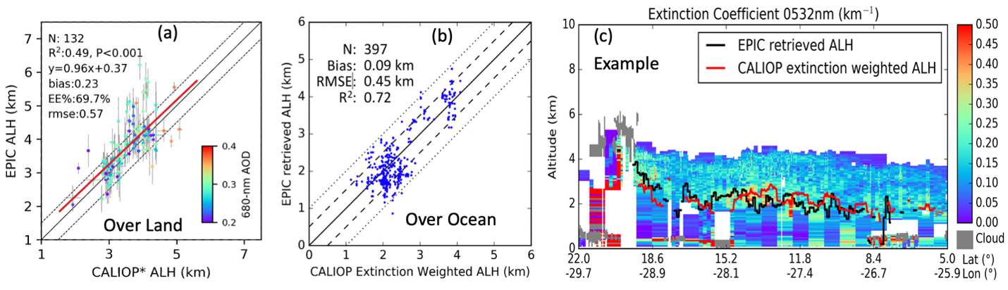
Figure 1. Intercomparison of EPCI AOCH with the AOCH computed from CALIPSO aerosol extinction profile. (a) over land, (b) over ocean, and (c) for a case study over the coastal ocean near Saharan desert. For details, please refer to Xu et al. (2019) and Xu et al. (2017).
What are the scientific applications of AOCH data product? Aerosol vertical distribution is one of the largest uncertainties in our understanding of global aerosol distribution and aerosol impacts on climate. It is also critical for atmospheric chemistry modeling, air quality forecast, and estimate of surface PM2.5 from AOD data. For the same value of AOD, the higher the AOCH, the lower the surface PM2.5. The scientific application of AOCH has just begun and continuous exploration of the application of these data may lead to advancement and insights in multiple fronts. Fig. 2 provides one example showing the potential value of EPIC AOCH data for improving estimate of surface PM2.5. It demonstrates that in areas with large AOD and AOCH values, surface PM2.5 can indeed be very low; whereas in areas where AOCH is low and AOD value is moderate, surface PM2.5 can be high.
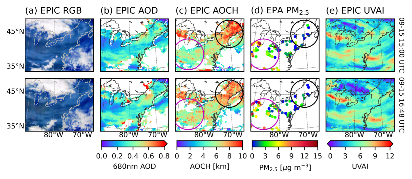
Figure 2. EPIC AOCH and its application on surface PM2.5 concentration. The first and second rows are for 15:00 and 16:48 UTC on September 15, 2020, respectively. (a) EPIC true color image, (b) EPIC 680 nm AOD, (c) EPIC AOCH, (d) EPA ground measurements of PM2.5 mass concentrations at 15:00 and 17:00 UTC, respectively, (e) EPIC UV aerosol index. For details, please refer to Lu et al. (2021). Data resource links:
https://asdc.larc.nasa.gov/project/DSCOVR/DSCOVR_EPIC_L2_AOCH_01
https://epic.gsfc.nasa.gov/science/products/aoch
References:
Chen, X., Wang, J., Xu, X., Zhou, M., Zhang, H., Castro Garcia, L., et al. (2021). First retrieval of absorbing aerosol height over dark target using TROPOMI oxygen B band: Algorithm development and application for surface particulate matter estimates. Remote Sensing of Environment, 265, 112674. https://doi.org/10.1016/j.rse.2021.112674
Lu, Z.*, J. Wang, X. Chen*, J. Zeng, Y. Wang*, X. Xu , K. E. Christian, J. E. Yorks, E.P. Nowottnick , J.S. Reid, P. Xian, First Mapping of Monthly and Diurnal Climatology of Saharan Dust Layer Height Over the Atlantic Ocean From EPIC/DSCOVR in Deep Space, Geophys. Res. Lett., 50, e2022GL102552, 2023
Lu, Z., Wang, J., Xu, X., Chen, X., Kondragunta, S., Torres, O., et al. (2021). Hourly Mapping of the Layer Height of Thick Smoke Plumes Over the Western U.S. in 2020 Severe Fire Season. Frontiers in Remote Sensing, 2. Original Research. 10.3389/frsen.2021.766628
Xu, X., Wang, J., Wang, Y., Zeng, J., Torres, O., Reid, J. S., et al. (2019). Detecting layer height of smoke aerosols over vegetated land and water surfaces via oxygen absorption bands: hourly results from EPIC/DSCOVR in deep space. Atmospheric Measurement Techniques, 12(6), 3269-3288. 10.5194/amt-12-3269-2019
Xu, X., Wang, J., Wang, Y., Zeng, J., Torres, O., Yang, Y., et al. (2017). Passive remote sensing of altitude and optical depth of dust plumes using the oxygen A and B bands: first results from EPIC/DSCOVR at Lagrange-1 point. Geophysical Research Letters, 44(14), 7544-7554. 10.1002/2017gl073939